
Measuring Tropical Forests and Deforestation from Space
Remote sensing is one important tool in the toolbox of forest governance for monitoring, measuring, and reducing deforestation
In a world where a swipe on a smart phone enables navigation from one part of the globe to another, many technology companies, investors, environmental organizations, community groups, and policymakers are looking to remote sensing data and platforms to increase transparency, accuracy, speed of decision-making, and reduce costs of monitoring land-based activities at scale.
Advancements in these platforms are aiding in improved detection of changes deforestation rates and forest carbon stocks, finetuning our ability to assess ecosystem health and pinpoint priority areas for restoration, supporting new monitoring, reporting, and verification (MRV) programs, and have even led to optimistic articles such as “Can Lidar Save the Earth?” At the same time, these technologies are tools – not a climate change solution in and of themselves – that must meet the needs of those using them and those effecting change on the ground.
In this post, we’ll explore how subnational government members of the Governors’ Climate and Forests Task Force (GCF Task Force) are considering ways in which remote sensing can help them address real-time needs in their forest governance efforts.
What is Remote Sensing
The National Aeronautics and Space Administration (NASA) defines “remote sensing” as the
“acquiring of information from a distance. NASA observes Earth and other planetary bodies via remote sensors on satellites and aircraft that detect and record reflected or emitted energy. Remote sensors, which provide a global perspective and a wealth of data about Earth systems, enable data-informed decision making based on the current and future state of our planet.”
Various government agencies, university labs, non-profit organizations, and private companies have been developing remote sensing data collection, processing, and utilization platforms for decades. A few examples include NASA’s Jet Propulsion Lab, the United States Geological Survey, Brazil’s PRODES, ESRI, FlintPro, Planet, Global Forest Watch, SERVIR (a joint initiative of NASA, USAID, and leading geospatial organizations around the world), and CTrees, to name just a few. Some of these entities design and launch large and small satellites that collect imagery or fly drones and airplanes equipped with increasingly sophisticated sensors. Others focus on the science of processing imagery and data and developing models and methodologies to analyze and make it available for decisionmakers on the ground.
Many of these organizations collaborate on advancing the state of the technology and science, including pairing machine learning algorithms and artificial intelligence to improve accuracy in forest monitoring and speed up data processing time.
Part of a growing toolbox for forest governance
With such exciting growth in this sector, an important question for GCF Task Force jurisdictions is how this technology supports their governance needs on the ground now and over time. Like with any governance question, the realities on the ground surrounding the tropical deforestation crisis are complex.
Consider for instance the types of questions that require answering to have a fuller understanding of the forest and forest cover being monitored. These may include:
- How much forest is there in the jurisdiction? (Think: forest inventory)
- What type(s) of forests and what species of trees are present? Does this impact the inventory or remote sensing platform’s functioning?
- Who lives in and around the forests, and who depends on this forest for their livelihood?
- What is the legal status of the forest and who has authority to recognize and advance these rights?
- What activities are taking place in the forest? Do those activities result in increased or decreased deforestation, and why? (Think: drivers of deforestation)
- How can we address those activities and reduce deforestation?
- Can we measure the ecosystem services provided by these forests? (Think: carbon or biodiversity markets)
- How do we assess changes over time? This is of particular importance to the GCF Task Force, as we assess the impact of jurisdiction-wide approaches to reduce deforestation. (Remote sensing has helped highlight some recent good news stories in GCF Task Force jurisdictions, including preliminary estimates of important reductions in deforestation rates in Brazil, Colombia, and Indonesia.)
- How much does this cost and how is it funded?
Remote sensing and other technologies can help with answering some of these questions, but only as part of a larger governance strategy. That strategy also needs to include building and strengthening relationships, responsibilities, and capabilities across government and within communities; clear laws and policies that are enforced; funding and governmental capacity; community-level and private sector partnerships; and political will.
GCF Task Force Remote Sensing Workshop
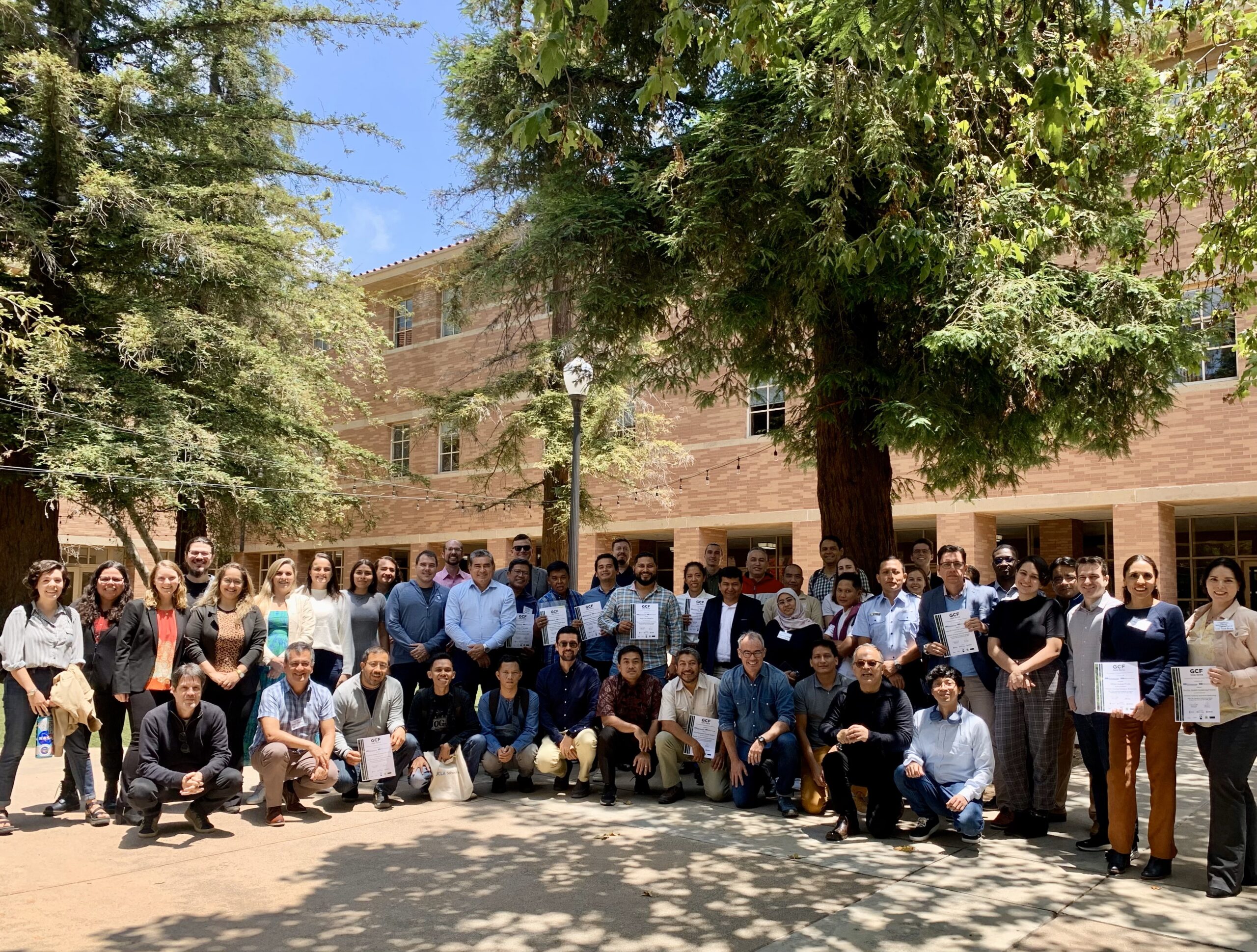
It is exactly this dynamic that the GCF Task Force sought to explore at a remote sensing workshop held at the University of California Los Angeles (UCLA) School of Law from June 5-8, 2023, through the Emmett Institute on Climate Change and the Environment and UCLA’s Institute of the Environment and Sustainability.
The workshop brought participants together to gain a better understanding of remote sensing data collection methodologies, geospatial tools, and data processing capabilities through direct engagement with experts from remote sensing organizations, faculty from UCLA, and with peers from across the GCF Task Force network. The GCF Task Force Secretariat facilitated the discussions to focus on the jurisdictions’ practical experiences with existing tools and specific needs to improve their capabilities.
In all, technical representatives from 26 (of 43) GCF Task Force member states and provinces, from 7 countries (Brazil, Côte d’Ivoire, Ecuador, Indonesia, Mexico, Peru, and the United States), joined with remote sensing experts from UCLA, Planet, Global Forest Watch, Servir, and CTrees to dig into (1) what data is available, (2) how is it collected, (3) how is it processed, analyzed, and used from a technical perspective, and (4) how it can best support resource management needs of the jurisdictions and improve forest governance decision-making.
Throughout the week, geospatial technicians described various programs in which they are (or hope to be) utilizing remote sensing in their work. Several jurisdictions discussed their early alert programs to detect land-use change, including deforestation due to illegal clearing and fires. Other use cases related to working with Indigenous Peoples and local communities to improve recognition of land title and protection, developing programs to support protected area management, improving transparency of all of these activities through better mapping and visualization tools that could be shared with the public, and developing more rapid assessments of carbon stocks and biomass that may assist jurisdictions in accessing climate finance through emerging carbon market and ecosystem services mechanisms.
Jurisdictional Use Cases & Challenges
Some jurisdictions have already developed sophisticated decision-making platforms within their environmental agencies through in-house remote sensing staff and/or through contracted technology partners. This was the case for illegal land clearing alert programs in the Brazilian States of Mato Grosso and Pará. Alex Marega, Executive Secretary of the State Secretary of the Environment of Mato Grosso, noted that these alert systems – which utilize Planet imagery – allow his agency to more effectively, quickly, and transparently detect illegal forest clearing and issue penalties to those causing the clearing. He also explained that this has created a strong deterrence effect to illegal activity and has “led to an increase in individuals registering their lands to obtain legal permits for planned land-use activities.”
Other participants discussed challenges they face in developing (and maintaining) the capacity to set up, process, and utilize these types of data platforms. For instance, many jurisdictions face significant turnover following gubernatorial elections. This has resulted in loss of institutional knowledge and the inability to invest in new data platforms, given the single-term nature of some governments. Peruvian participants explained that one way they are addressing this challenge is through a recent cooperative partnership with the Peruvian Air Force to aid regional governments monitor the Amazon through the national Centro de Vigilancia Amazonica y Nacional (CEVAN).
Other jurisdictions discussed realities with forest inventories in their countries, such as the lack of inventory data, or in the case of some countries, the legal requirement to only utilize approved, nationally released data. The expert trainers discussed potential ways their platforms could be used to complement existing national data by helping subnational governments bolster their data understanding or providing data-checks and are already following up with participants to explore additional ways to support them in their data needs.
All partner organizations mentioned how valuable it was for them to hear directly from end-user government agencies so they can work on further improvements and updates to their platforms.
Needs Going Forward
On the final day of the workshop, participants discussed potential next steps to keep moving forward in terms of their understanding, use, and co-construction of these data platforms. Many of them indicated that to most effectively track progress and impacts of policies and actions on the ground, especially related to monitoring illegal land-clearing, they look forward to receiving real time alerts, as opposed to “near-real time” monitoring capabilities. Given current data processing times and needs, several of the remote sensing experts indicated this is not currently possible.
Several participants also discussed the need for governments to show their work and provide information (including remote sensing maps) publicly. This raises interesting questions of the public versus proprietary nature of some of the data platforms, as well as cost implications for governments to utilize these platforms. These points were raised throughout the week and will continue to be an important discussion going forward.
Additional technical questions arose related to ensuring that uncertainty bounds are clearly described in any methodology that relies on remotely sensed data. The experts explained how their organizations include that information within their platform materials. Several jurisdictions mentioned challenges with storing large amounts of data and the desire for increased opportunities to develop in-house capacity within their agencies.
Finally, multiple jurisdictions expressed their appreciation of something called the NIFCI Satellite Data Program, through which Norway’s International Forest and Climate Initiative (NICFI) provides (for free) access to some of Planet’s high-resolution imagery through the end of 2024. At the same time, participants had questions for how long this imagery would be made available in the future. They all expressed their hope that the imagery would continue to be accessible and updated in the long run.
Lessons from Jurisdictional Approaches & Capabilities
Key take-away lessons from this workshop included: (1) GCF Task Force member jurisdictions already use remote sensing data in their decision-making and they are interested in increasing their capacity to continue doing so; and (2) to increase the effectiveness and uptake of remote sensing technologies, providers and tool developers must work hand-in-hand with data users from these governments who will be assessing how these tools can improve the technical work that supports their recommendations to decision-makers for forest governance decisions and outcomes on the ground. Only through this type of engagement will the technology be able to keep up with the many different tools in a government’s forest governance strategy and vice versa.
Supporting these types of engagements is an important way to expand access to emerging technology and data that can help jurisdictions take and measure action and assess results. This workshop provided an excellent opportunity for peer-to-peer exchange between GCF Task Force member jurisdictions and between the jurisdictions and expert technology platforms. The GCF Task Force looks forward to building on this first workshop with additional exchanges in the future.

About Jason
Jason Gray is Project Director, Governors' Climate and Forests Task Force, at the UCLA Emmett Institute on Climate Change and the Environment.…
READ more
Reader Comments