
The New Frontier of Methane Regulation
Nations, companies, and NGOs are targeting methane like never before using satellite data. A new UCLA paper outlines what that could mean for regulation.
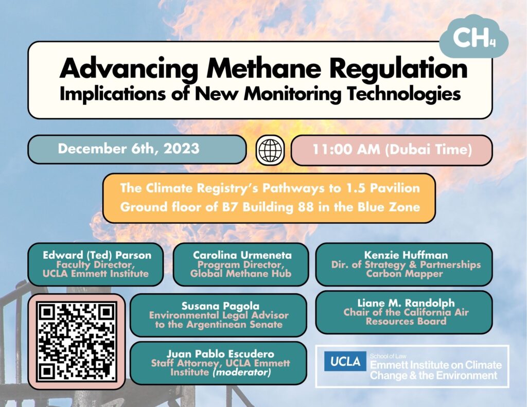
Methane is ready for its close-up. The first week of COP28, the UN climate talks taking place in Dubai, saw a handful of big announcements about how world leaders plan to tackle human-made climate change by targeting methane, a powerful short-term climate pollutant. The UCLA Emmett Institute is also drawing attention to the issue of methane. Several members of the Emmett Institute team are at COP28, where we are hosting a side event on methane in conjunction with the release of our new discussion paper, “Advancing Methane Regulation: Implications of New Monitoring Technologies.”
To recap: The Biden administration announced Saturday that it would, for the first time, require oil and gas producers to detect and fix methane leaks from their operations, create more stringent monitoring provisions, and eliminate the routine flaring of natural gas. That announcement came from EPA Administrator Michael Regan in the form of a final methane rule by his agency, which takes effect next year. Also on Saturday in Dubai, about a dozen philanthropies announced they will invest $450 million over the next three years to help countries launch national actions to tackle methane. And California officials who are attending COP28 officially launched the Subnational Methane Action coalition to collaborate with other jurisdictions on best practices to reduce methane emissions.
As for the oil industry itself: Fifty oil companies representing nearly half of global production pledged to reach near-zero methane emissions and end routine flaring in their operations by 2030. That announcement came from Sultan al-Jaber, the embattled president of COP28 who heads the Abu Dhabi National Oil Co. The industry’s methane pledge has been greeted, understandably, with skepticism both because of the absence of some key players and the fact that it ignores one large aspect of the problem: fossil fuel consumption.
So, everyone in the world has set their sights on methane, which U.S. climate envoy John Kerry calls “the easiest, quickest, fastest, cheapest way” to make gains on global warming. Emitters can adopt many methane abatement practices and technologies at low-to-negative net cost. As we’ve seen over the last few days in Dubai, the low cost and technological feasibility of methane abatement (particularly in the oil and gas sector) means that governments and industry alike can cash in on good publicity by picking these low-hanging fruit while, in some cases, achieving cost savings by capturing and utilizing methane that would otherwise be vented directly into the atmosphere.
But there’s a catch. Methane, a colorless, odorless gas, is hard to detect and, therefore, hard to abate. This means that huge methane leaks, which contribute to a disproportionate share of methane emissions, have long gone unnoticed or unaddressed. It also means that national methane inventories, including those published under the United Nations Framework Convention on Climate Change, have resorted to using “bottom-up” estimates, which estimate methane based on standardized emissions factors multiplied by activity levels. However, these bottom-up estimates generally fail to account for large super-emitter events and may reflect outdated or otherwise inaccurate studies. Because of these issues, there has been an increasing scientific consensus that current methane inventories greatly underestimate actual methane emissions. Moreover, the fact that these inventories often rely on self-reported estimates makes it difficult to confirm the veracity of their numbers.
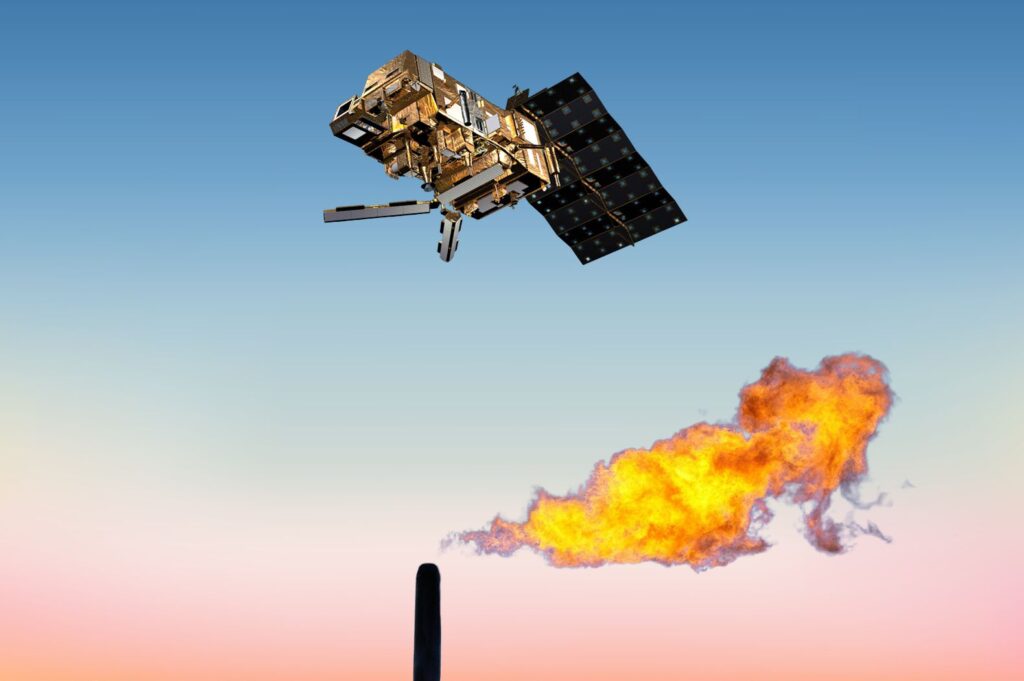
That’s where remote sensing technologies come in. Over the last ten years, methane detecting technologies––mounted on satellites, aircraft, and ground-based platforms––have become increasingly advanced, capable of detecting methane at global, regional, and facility scales. In several high-profile instances, they have been used to pinpoint massive leaks at upstream and downstream fossil fuel facilities; help jurisdictions enforce existing methane regulations; and more accurately quantify emissions across large oil and air basins. But, as with any nascent and transformative technology, regulators have struggled with the tricky business of connecting these new methane detection technologies with the regulatory schemes needed to actually enact controls for the super pollutant.
This intersection between remote sensing technology and methane regulation is what our Advancing Methane Regulation Project has set out to explore. In October, we released a global survey of methane regulations in advance of a two-day workshop at UCLA that brought together experts on technology, law, and policy. Using the insights from this workshop and survey, the Emmett Institute has released this new discussion paper that seeks to explore possible regulatory pathways that incorporate remote sensing technology, while also identifying new technological capabilities and the key challenges to adopting these regulations. We’ll be talking about all this at COP28.
Several jurisdictions have already taken significant steps towards incorporating methane remote sensing into their regulatory and enforcement schemes. Both the California Air Resources Board and the US EPA have approved rules that would allow third-party satellite operators to help enforce methane regulations, with EPA allowing credentialed third-party remote sensing operators to trigger leak detection and repair requirements directly. In Colorado, which in 2014 became the first US state to regulate methane emissions directly, a pair of recently enacted rules regulate the production intensity of upstream oil and gas operations, with the state deploying its own remote sensing technologies. These rules are instructive in several ways, demonstrating the feasibility of formalizing processes for using remote sensing in enforcement and leak notification and repair. Moreover, several jurisdictions are exploring the possibility of incorporating remote-sensed data into national emissions inventories to correct the above-mentioned problems with bottom-up emissions inventories.
Although these jurisdictions have demonstrated leadership in incorporating these burgeoning technologies into existing regulatory schemes, it’s likely that we’ll see these new data used in increasingly novel ways. In the coming years, remote sensing technology may provide new pathways for regulating methane emissions from agriculture, coal, and waste sectors, both by providing observational capabilities for more diffuse emissions sources across larger areas and by tracking methane emissions at facilities designed to collect and channelize these emissions, such as digesters or coal mine gas collection systems.
Other emerging opportunities may involve the use of remote sensing––which can provide methane emissions observations across international borders––in cross-border methane regulation and pricing schemes. Both the United States and the European Union have considered regulatory schemes that would impose costs on jurisdictions seeking to import goods into their jurisdictions based on their carbon footprint. Professor Kim Clausing, who spoke at the October workshop, has drafted papers discussing the possibility of applying similar frameworks to methane emissions, supplemented by remote-sensed data provided via satellite.
The discussion paper further identifies themes relating to the cooperative exchange of remote sensing data, including the free and open exchange of remote sensing data across jurisdictions, allowing developing countries to incorporate methane data that may otherwise be cost-prohibitive. Relatedly, the paper discusses the issuance of grants and direct provision of remote sensing data access and technical training to communities located near high-emitting industries, which could improve health and safety outcomes for local communities and boost oversight capacity.
There are inherent difficulties in translating highly technical and emerging technologies to clear regulatory schemes in a manner that is understandable to regulators. The discussion paper concludes by considering the challenges related to filling gaps in data and reconciling inconsistencies in the remote sensing instruments that are available to policymakers, third parties, and facility operators.
COP28 is the ideal staging ground for a thoughtful discussion on the possibilities––and challenges––related to implementing comprehensive remote sensing regimes across the world. With the (rightfully) increasing global focus on methane abatement, it is critical for regulators to use every tool in their toolbox to fight the climate super pollutant. And, as highlighted by the discussion paper, remote sensing technologies may be a very powerful tool for governments in the near future.
About Gabriel
Gabe Greif is an Emmett/Frankel Fellow in Environmental Law and Policy at UCLA School of Law for 2022-2024. He was previously an Emmett Family Public Service Fellow in En…
READ moreAbout Evan
Evan George is Director of Communications for the UCLA Emmett Institute, a leading environmental law center. He also writes The Drain, a weekly roundup of environmental a…
READ more
Reader Comments