























































The Bottleneck in Forest Monitoring Isn’t in Orbit
Groups on the frontlines fighting deforestation are held back by institutional constraints – not just technological barriers – according to a new study from UCLA, NYU, World Resources Institute, and the Governors’ Climate and Forests Task Force.
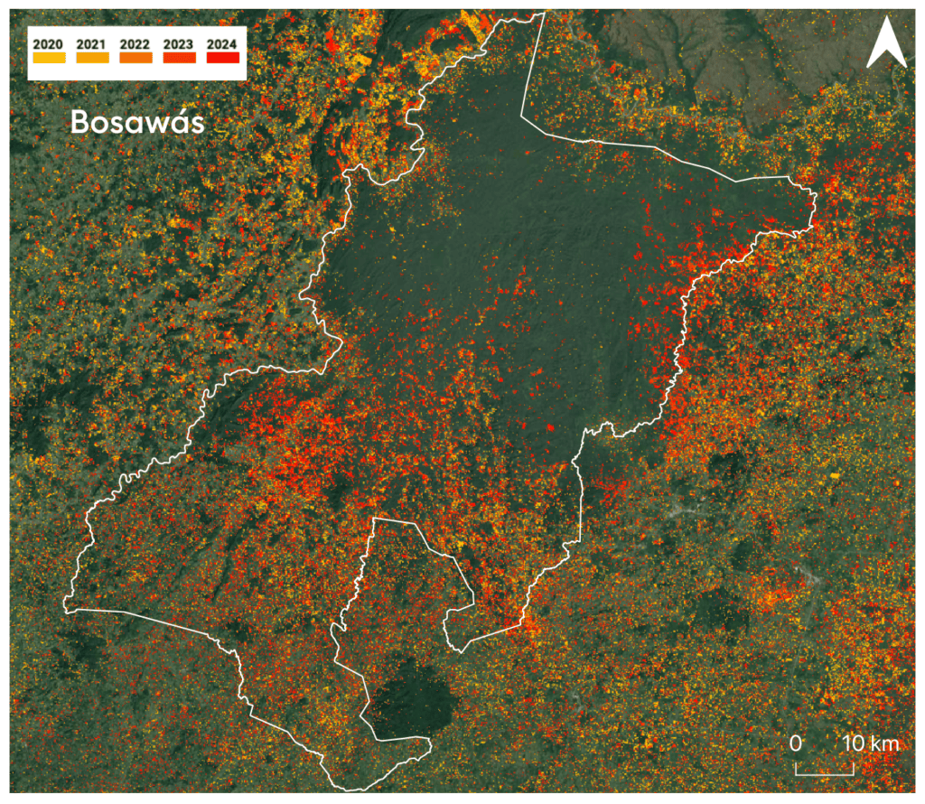
There are 16,000 satellites circling the Earth right now, and a growing share of them capture images of our planet in unprecedented detail at every moment of the day. One of the many things they measure, monitor, and observe are forests. Being able to measure forests is the foundation for protecting them and for decades there have been efforts to get satellite data and remote sensing tools into the hands of the people who actually govern those forests. Underlying these efforts was the techno-optimist assumption that if the data is freely available, it will be used by frontline actors and thus have a substantial impact on deforestation and degradation in the world’s tropical forests.
And yet, the integration of remote sensing into decision-making processes remains challenging as practitioners on the ground still struggle to utilize this technology effectively, despite decades of technology transfer and capacity building efforts. This raises the question why these efforts may have fallen short, and whether there are ways to change how remote sensing capacity should be built going forward. We at UCLA’s Institute of the Environment and Sustainability and the Governors’ Climate and Forests Task Force (or GCF Task Force) set out to answer some of these questions by talking to key stakeholders across the remote sensing value chain about how they are using remote sensing tools and data and what obstacles they encounter in day-to-day use.
This is the first of two posts on why remote sensing keeps underdelivering on its promise for forest protection. This one is about the challenges practitioners actually run into. The second is about why the field keeps failing to see it.
CONTEXT
Satellite images have gone from classified government infrastructure to being instantaneously accessible on your phone. They are now used in a range of applications, from agriculture to urban planning, disaster response, real estate, and water resource monitoring. For forest management specifically, remote sensing is now indispensable: it shows deforestation in near-real time, can penetrate canopy cover, and detect the health of the ecosystem across territories that are otherwise too vast, too remote, or too dangerous to patrol and research. Remote sensing is at its heart a technological endeavor and rooted in a history of scientific discovery and engineering marvels. As such, the predominant discourse around remote sensing and its application in forest management and conservation has been technical, and one topic has stood out in particular: open access to data.
The movement for making satellite data public has been hugely successful. Brazil’s space agency was the first to open up mid-resolution imagery to the public in 2004. USGS made the full Landsat archive available in 2008, the EU adopted “free, full and open” for Copernicus in 2013, and the Japanese space agency JAXA released global radar forest maps in 2014. Yet another milestone was hit when in 2020, the Norwegian government entered an agreement with the private satellite company Planet to make their high-resolution data available. The Planet-NICFI dataset meant that everyone with an internet connection could download a monthly, sub-5-meter satellite picture. The availability of high-quality data for free had a huge impact on the remote sensing community: user numbers exploded and states like Mato Grosso and Pará built deforestation alert systems based on this imagery. Yet, despite free data and easy-to-use tools, users in subnational governments, NGOs and small enterprises still struggled to fold remote sensing into their day-to-day processes and decision making. The conventional explanations mostly revolve around availability of even higher-resolution data, data quality (specifically accuracy and local calibration), and technical skills. Given the seeming contradiction of this line of reasoning with the ever-increasing amount of free data and tools, we wanted to know if there are other barriers to the uptake of remote sensing.
WHAT WE DID
We interviewed 38 key stakeholders at every point along the remote sensing value chain, from civil servants monitoring forests in Indonesian Papua and the Peruvian Amazon, Indigenous organizations mapping their territories, development bank advisers, and executives at satellite companies. We asked two things: What challenges do you have when using remote sensing data and tools? And what are the biggest barriers to building remote sensing capacity in your organization?
WHAT WE FOUND
We found that an institution’s capacity to effectively use remote sensing rests on four elements: (1) dependable access to data, (2) technical expertise, (3) organizational support, and (4) equitable relationships. If one of these elements is missing or gets undermined, achieving or maintaining institutional capacity becomes much more difficult. Our interviewees confirmed the conventionally described barriers to capacity building – access to data and technical expertise – still hold true. In addition, we identified two other elements of capacity that often get crowded out in the techno-centric discourse around remote sensing: organizational support that results in clear mandates for data users, and equitable partnerships with the people and organizations who provide the data and build the tools. During our interviews, participants described their day-to-day challenges to using remote sensing data and tools – what we call operational frictions. Notably, these frictions, though, do not appear from nowhere. Rather they are rooted in and produced by the deeper, underlying conditions of the institutions in which the users operate – the rules, budgets, mandates, cultures, and people that make up their organizations.
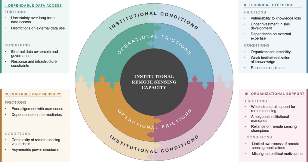
These institutional conditions and operational frictions manifest in very pragmatic and mundane ways. For example, technical expertise often concentrates in just a few people in the organizations, and disappears when these people leave, creating the challenge of retaining institutional knowledge in the face of staff turnover. The conditions that give rise to this friction are short-term contracts, political cycles that reassign staff, higher salaries in the private sector, and poor documentation or onboarding processes to retain knowledge in the institution.
“The problem is, ‘we’re all just birds that are passing by’ [local saying]. If I die tomorrow, all the knowledge goes with me. The challenge is to create that document that has permanence of information.”
— Cartography specialist, regional government, Peruvian Amazon
“Just so you know, in my department, I am the second oldest there, and I’ve not even been there for three years.”
— Forest engineer, state environment secretariat, Brazilian Amazon
Some interviewees also reported that there are no dedicated budget lines in their organizations to support their activities, that positions are often not permanent, and their work mandates – meaning the guidance and objectives on how to use remote sensing and what to achieve with it – are unclear. Again, these frictions are rooted in institutional conditions, such as a certain naivete about remote sensing and its capabilities: senior decision-makers don’t know what remote sensing can do, or they may have different political and personal priorities.
“Many of our political leaders are unfamiliar with this technology, and the result is the wrong consideration, or a kind of neglect in terms of the funding that the government accord[s] to this domain of remote sensing.”
— Official, national space agency, Central Africa
Other frictions relate to data. For example, interviewees mentioned the issue of uncertain access – whether due to future budgetary changes or continued availability of specific data sources – and restrictive rules and regulations that demand the use of official government data, even if higher quality data exists. Again, these frictions are rooted in deeper institutional conditions such as budgetary constraints and concerns over sovereignty and control when data is produced and governed by third parties. In Indonesia, for example, provincial staff are only allowed to use data that is produced and sanctioned by the federal government for official purposes, which is often late and may not be the best data available for the task at hand.
“We cannot get the data real-time. […] The bureaucracy is just taking too much time.”
— Provincial forestry official, Indonesia
And lastly, we found that end users are rarely part of designing the tools meant to serve them. Instead, downstream organizations often rely on consultants to set up and operate remote sensing systems – with varying degrees of success. One reason for this is that the remote sensing value chain is long and complex: agenda-setting authority typically sits upstream – with funders, providers, and national ministries. Often, engagement by data providers and funders stops at the national level, so training and tailored tools reach users on the ground only when an organization has built appropriate processes for passing information down. Information moves poorly in the other direction too: on-the-ground users often have no channel to feed specifications or feedback into how tools are designed, meaning that their needs are less likely to be incorporated into the tools built to serve them.
“Each time you get a consultant to do work for you, at the end of the day you remain a spectator. Because once the consultant is done and is gone, sometimes even the data you don’t have it. They give you the report, and you don’t have the data.”
— Director, national climate change observatory, Central Africa
UNEQUAL DISTRIBUTION
Notably, we found that these patterns are not evenly distributed and appear to be the worst at the periphery of the value chain with actors in subnational governments, Indigenous organizations, and local civil society groups reporting the most frictions. Similarly, poorer countries and regions reported more issues with basic infrastructure and skills, such as stable internet, access to hardware and software, and lack of foundational skills among candidates when recruiting. Incidentally, these are the geographies and actors who are closest to the deforestation frontiers and who are held back from accessing the appropriate data and tools.
SO WHAT
In summary, we find that the barriers that users of remote sensing data and tools experience are institutional, regulatory and procedural, not just technical. A report by Deloitte and the World Economic Forum estimates the value of remote sensing information to be $266 billion in 2023, rising to $703 billion by 2030. In the same report, industry leaders state that the constraints for growing the remote sensing industry are located on the demand side, not the supply side. In other words, the technology is already outpacing its user base. So, where does this leave the remote sensing community? Maybe these are signs to raise the floor and channel more funding and efforts towards overcoming the barriers that frontline users experience on a day-to-day basis.
It is critical to recognize that many of these obstacles are specific to the organizations and people within them and will vary across time and geographies. Our findings show that capacity is made up of multiple, interrelated elements and that addressing them in isolation is not likely to result in sustained success. For example, providing open data will not benefit end users when they have no clear mandate to use that data. Training staff who will leave the organization in two years because of budgetary constraints will not create institutional capacity.
Capacity building interventions must understand the institutional conditions that give rise to the problems they are trying to address. The hard truth that follows from this is that the most impactful efforts are local and therefore hard to scale – something that is unfortunately not rewarded by today’s short project cycles and demand for high-visibility deliverables.
“The biggest obstacle to improving capacity for forest monitoring are institutional arrangements. It’s not something you can throw one big flashy program at, like a nice label: ‘The Capacity Program now with a flashy Californian tech company’, and expect results.”
— Senior adviser, European development agency
Funders need to recognize that one-size-fits-all solutions are unlikely to exist and should consider adjusting how they design programs and deliverables so that they can deliver sustained growth for frontline actors. None of this requires reinventing the wheel. Programs that do the slow and deliberate work already exist. For example, the SERVIR project, originally launched in 2005 as a joint initiative of NASA and USAID, has been building remote sensing capacity across Asia, Africa, and Latin America. Instead of providing tools and trainings in a top-down fashion, it created regional hubs inside institutions that already existed and co-developed services together with national agencies that would use them, rather than delivering a finished solution. This approach even survived the withdrawal of USAID and NASA funds in 2025, and SERVIR continues to exist as an alliance of independent regional hubs steered by their own members.
CONCLUSION
Remote sensing technology has transformed beyond recognition over the past two decades and today provides unprecedented opportunities for leveraging space-based imagery and information technology for forest protection. However, without addressing the institutional side of remote sensing these advancements are unlikely to be fully utilized by the actors that matter most – on-the-ground users and decision makers that are on the frontlines of fighting deforestation and degradation across the globe. Engaging with the institutional context therefore needs to become integral to future capacity building efforts. Only then can free data and advanced tools have the impact that has been promised all along.
The full study, “Institutional dimensions of remote sensing capacity for tropical forest monitoring,” is published open access in Environmental Research Letters and is free to download.
I am grateful to my co-authors Elsa Ordway (UCLA), Kim Carlson (NYU), Denis Sonwa (WRI), and William Boyd (UCLA), for the work and ideas behind this study.
Reader Comments
One Reply to “The Bottleneck in Forest Monitoring Isn’t in Orbit”
Leave a Reply

About Marius

Marius von Essen is a postdoctoral scholar at the Institute of the Environment and Sustainability at the University of California in Los Angeles. With a PhD in Earth Syst…
READ more
It boggles my mind to think about 16,000 satellites in orbit around the Earth.