
Mapping City Priorities for an Equitable EV Infrastructure Rollout
How can cities identify high-priority, high-feasibility, high-utility sites?
As state regulators and auto manufacturers begin the drive toward 100 percent zero-emission vehicle sales by 2035, leaders across California face a daunting challenge. How can they ensure that all Californians–not just those who can afford a new EV and a charger in their garage–have access to affordable, reliable, and convenient vehicle charging that meets their travel needs and improves quality of life and mobility (or, at a minimum, does not diminish them)? It’s a complex question, but here are a few things we do know:
- Public charging and electric vehicle adoption go hand in hand
- Disadvantaged and underserved California communities have been less likely to access state EV purchase rebates and have experienced less air quality improvement since their introduction
- Lower-income and nonwhite Californians are less likely to have access to public charging
- Nonwhite Americans are equally or more likely to be interested in an electric vehicle, but also are more likely to live in rented and multifamily dwellings – two of the most significant barriers to installing and accessing private vehicle chargers
CLEE’s EV Equity Initiative is seeking to address this challenge through the lens of city-level policies that will likely involve installing chargers at curbside and in the public right-of-way; in large parking lots at community facilities like schools, churches, and libraries; and at and near apartment buildings. Not all cities will be directly involved in the siting and deployment process, but all cities will have to work across government, industry, and communities to bring targeted investment and policy support to high-priority locations.
This is a multi-layered task, and one of the first steps is to identify where those locations are: Which populations and neighborhoods will need the most proactive support? Where and when are residents likely to charge vehicles? What are existing travel dynamics and how do EVs fit within the rest of the transit network? Where can the grid and buildings support new chargers and where are upgrades needed? What commercial, educational, and recreational sites are interested in hosting chargers and where do community members want them?
UC Berkeley graduate students Ankita Suresh Shanbhag (MIMS ‘24) and Eleanor Adachi (ERG ‘24) working with Professor Dan Kammen are helping us develop a mapping framework to answer these questions. By layering relevant geospatial criteria, we can identify where cities might want to focus their policies and investments–and crucially, by allowing users to select and order layers as they see fit, we can provide city leaders and communities with a tool to make their own locally appropriate decisions about charging priorities.
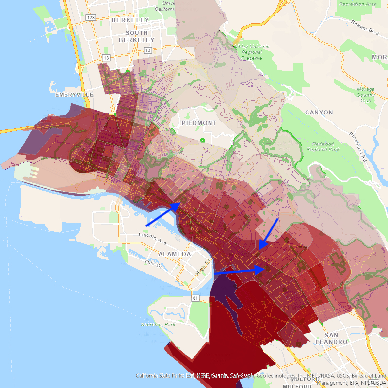
We are still developing the tool, but an early example from Oakland demonstrates how city teams and stakeholders might use the information. First, to identify high-priority communities, we might look at CalEnviroScreen 4.0, which assesses California census tracts by a mix of pollution burdens/exposures and demographic indicators to identify communities most vulnerable to environmental harms:
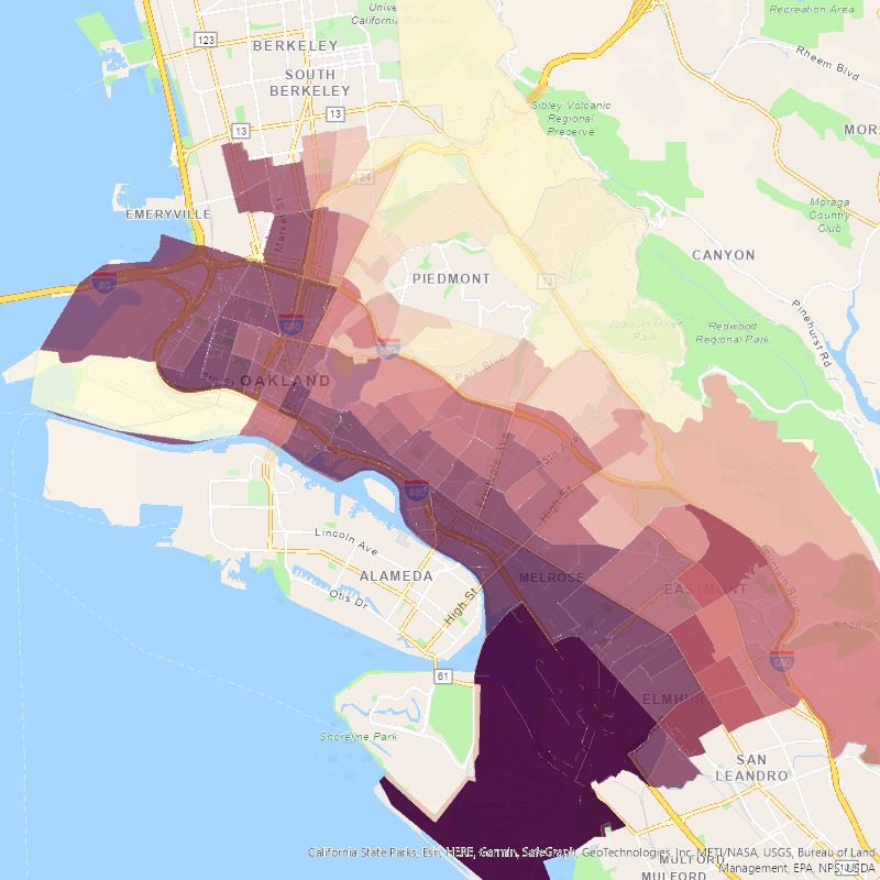
Then we might layer on Oakland’s own Environmental Justice Communities Map, which refines the state approach by tailoring some indicators to the Oakland context and adding criteria such as extreme commutes. In practice, the city might only choose to use its own map, but for illustrative purposes, layering the two demonstrates how a user could highlight communities that meet the highest proportion of both local and state criteria–shown here in dark overlapping red and purple:
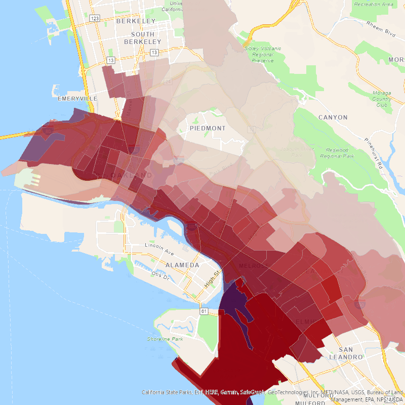
Then we might ask where the existing electrical grid can support new energy-intensive charging infrastructure, which is reflected in utility integration capacity analysis (ICA) maps. Here, the distribution grid branches in yellow show more available capacity (i.e., better candidate locations for chargers) and purple lines show less available capacity):
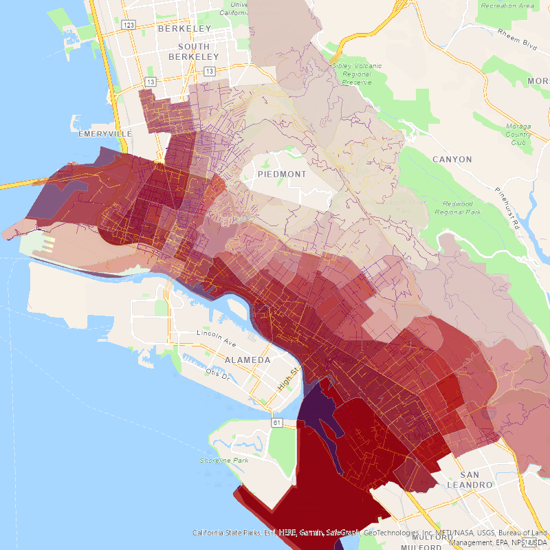
Finally, we might ask where residents might be interested in parking for enough time to get an adequate charge (i.e., 30+ minutes for a fast charger or 120+ minutes for a Level 2 charger)–for example, public parks with parking spaces, shown here in darker green:
What does this rough draft reveal? Potential areas of focus near International Boulevard such as Carter-Gilmore Park, Rainbow Recreation Center, and San Antonio Park, among others. (It also shows that the data need refinement, as some of the areas currently indicated as park facilities are really just open/undeveloped spaces without park amenities, or green street medians.)
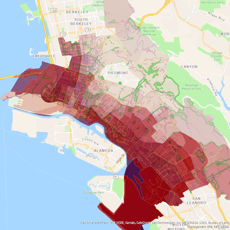
These are just a few sample criteria–equally or more important will be things like commercial corridors, major multi-unit dwellings, community facilities like schools and libraries, parking meters, trip dynamics, and federal infrastructure funding zones. As will be an easy-to-use web interface and sharp, granular graphics. And any map-based depiction is only the start of a conversation with community members, business leaders, property owners, and city staff to match what might be high-priority or feasible with what is desired and needed.
These are likely areas that city leaders and community members can also readily identify as high-priority based on local knowledge and preferences. But ensuring all stakeholders–public sector, private sector, and individual residents–have access to this type of information, with the ability to tailor their analysis to the local context, will be crucial to ensuring equity in the EV transition.
Reader Comments
3 Replies to “Mapping City Priorities for an Equitable EV Infrastructure Rollout”
Comments are closed.
About Ted
Ted Lamm is CLEE’s Associate Director. In this role, he coordinates CLEE’s Research Fellow program and leads CLEE’s EV Equity Initiative, a multi-year effort to dev…
READ more
Missing from your plan:
1) Prohibitive cost of buying new cars, including EV’s, for lower income and working people.
2) Removal of parking for people who cannot afford EV’s.
3) Cost of EV chargers to private users and the general taxpayers.
Hi Mary, the cost of vehicles is indeed a major barrier, though the major state and federal rebate programs, which are both income-capped, can bring costs down significantly. In addition, the Inflation Reduction Act extended the purchase credit to used EVs, which will become a viable option (just like used internal combustion engine vehicles are today) as more new EVs are sold and age over time.
Addressing the cost of installing chargers is a huge issue that we absolutely need to address. Fortunately, once installed, electricity is generally cheaper (and better for everyone’s health!) than gas.
Ultimately, mapping high-priority locations is just one step among many. Affordability and financing are crucial too, just not the focus of this post.
Thanks for your thoughts about the unsolved problem about those of us who cannot afford to buy EV’s.
I still see no answer about DISPLACING people from parking spaces for EV charging stations for the convenience of the affluent 2 percent.
Most lower income people cannot afford to buy ANY new vehicle, are largely renters who need parking for the vehicles they already own and need. This is one more ivory tower DISPLACEMENT program, in this instance mapping out where you propose to REMOVE parking and replace it with expensive EV chargers. You “map” that displacement with bright virtual crayolas for the convenience of oblivious legislators who don’t get it, just like you don’t get it.