
How Methane Satellites Work and Why it Matters
This new UCLA Law report aims to help policymakers understand the science and utility of methane satellites.
These days, I’ll take progress on climate change where I can get it. And one place to look right now is up — literally. New satellites are providing never-before-seen data about global methane sources, helping policymakers, industry, and others target that superpollutant in new ways. Today, some colleagues at UCLA Law and I are releasing a new report aimed at helping policymakers understand these new tools, along with their uses and limits.
With this report, we aim to respond to a need we’ve heard again and again over the last year, as the Earth science community has made serious strides in understanding global methane emissions using satellite imaging. Policymakers are excited by these developments but they also confront significant barriers in trying to use these new data streams. Often, policymakers don’t have a good understanding of how satellites work, what data comes from them, or what the opportunities and limits of those data are. Gaps in understanding hinder the usability of the information.
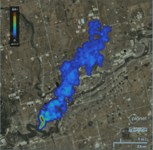
Overcoming these barriers is really important. As many of you know, methane is a climate superpollutant generated by oil and gas operations, landfills, coal mines, and agricultural sources. Reducing methane is the “power boost” of climate policy goals — it’s tractable and can make a real difference in warming. But to improve methane controls, you have to know where it’s coming from, and you have to understand and trust the information being presented about methane sources.
Our report hopes to help bridge this scientific/technical/policy gap. My colleagues Ted Parson, JP Escudero, Anna Veldman and I worked with a range of scientific experts and reviewers to create an accessible primer for regulators on how methane satellites work, what information they provide, and what their advantages (and limitations) are for helping to advance methane control. One goal is to better equip regulators to use the powerful new data platforms on methane emissions that incorporate satellite data, such as those from Carbon Mapper, WasteMap, and MethaneWatch. (If you haven’t spent time playing around with those data portals, especially the Carbon Mapper one, I highly recommend doing so. It’s pretty amazing what information is available.)
This report is the latest product of our UCLA Emmett Advancing Methane Regulation project, with support from the Global Methane Hub and others. Earlier this year we collaborated with our UC Berkeley CLEE colleagues, who have organized the Subnational Methane Action Coalition, on a general guide for policymakers on the promise of methane satellites; and future work will build on these foundations with additional implications for policymakers’ efforts to reduce methane in jurisdictions around the world.
Read the report here and please do share it around.

About Cara
Cara Horowitz is the executive director of the Emmett Institute on Climate Change and the Environment at UCLA School of Law. The Emmett Institute was founded as the firs…
READ more
Reader Comments